NOAA weather satellite images & sounds

Antenna : APT-2CP (Hamtronics)
Receiver : R139 (Hamtronics)
Program : WXtoImg (Freeware)
Weather Satellites
NOAA-15 : 137.620 1702.500 MHz
NOAA-17 : 137.500 1698.000 MHz
NOAA-18 : 137.9125 1707.000 MHz
NOAA-19 : 137.100 1698.000 MHz
R139 Settings
Channel 1, 137.100 MHz
Channel 2, 137.400 MHz
Channel 3, 137.500 MHz
Channel 4, 137.620 MHz
Channel 5, 137.9125 MHz
NOAA weather images #1 Jul 06 - Jul 23, 2005
NOAA weather images #2 Jul 23 - Sep 24, 2005
NOAA weather images #3 Oct 02 - Sep 20, 2006
NOAA weather sounds 12 May 28, 2006 137.500 MHz (Deleted)
NOAA weather sounds 15 May 28, 2006 137.620 MHz (Deleted)
NOAA weather sounds 17 Feb 02, 2006 137.500 MHz (Deleted)
NOAA weather sounds 18 May 01, 2012 137.9125MHz (Deleted)
NOAA weather sounds 19 Apr 08, 2012 137.100 MHz (Deleted)
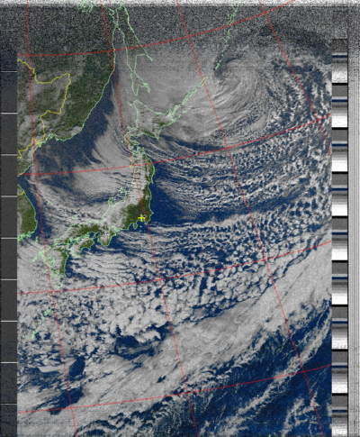
NOAA-17 over Japan on 8 Jan 2007
 2nd, 3rd Feb 2008
 WXtoIMG setup
(1) Options - Ground Station Location
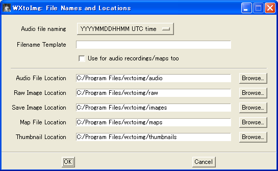
(2) Options - File Names and Locations
(3) Options - Image and Movie Options
(4) Options - Auto Processing Options - Image Settings
(5) Options - Auto Processing Options - (Check)Create images
(6) Options - Recording Options
(7) Options - Save Options
(8) File - Update Keplers
(9) File - Record - Auto Record
When oblique line,
(10) Options - (Check) Disable PLL
(11) Projection - Normal
(12) File - Open Audio File - Select
(13) Image - Slant Correction
(14) Draw a red line with the mouse along an oblique line in the image.
(15) Select "Estimate and set sampling frequencies for all satellites"
(16) Click "Set" button
(17) Options - (Uncheck) Disable PLL
(18) File - Auto Process
(19) Options - Save Options
WXtoIMG setup
(1) Options - Ground Station Location
(2) Options - File Names and Locations
(3) Options - Image and Movie Options
(4) Options - Auto Processing Options - Image Settings
(5) Options - Auto Processing Options - (Check)Create images
(6) Options - Recording Options
(7) Options - Save Options
(8) File - Update Keplers
(9) File - Record - Auto Record
When oblique line,
(10) Options - (Check) Disable PLL
(11) Projection - Normal
(12) File - Open Audio File - Select
(13) Image - Slant Correction
(14) Draw a red line with the mouse along an oblique line in the image.
(15) Select "Estimate and set sampling frequencies for all satellites"
(16) Click "Set" button
(17) Options - (Uncheck) Disable PLL
(18) File - Auto Process
(19) Options - Save Options


 NOAA-19 launched
NOAA-N-Prime (NOAA-19) launched at 10:22UTC, 6 Feb 2009.
WXtoImg Version 2.9.4 Released.
This new version supports NOAA-19. (137.9125MHz)
NOAA-19
1 33591U 09005A 09037.47464079 -.00000043 00000-0 00000+0 0 16
2 33591 098.7318 346.7380 0015655 243.2097 116.8530 14.10795454 03
http://www.nasa.gov/mp4/312237main_van_020609_noaa_launch_pod.mp4
http://www.f1afz.fr/satellites/sat_meteo/satellites_meteo.php
http://www.nasa.gov/mission_pages/NOAA-N-Prime/main/
http://www.oso.noaa.gov/news/index.asp
http://www.dk3wn.info/p/?p=2658
http://www.wxtoimg.com/
NOAA-19 first recorded
NOAA-19 is now transmitting sensors 1 & 2, which is the only time the
vegetation enhancement can be used to produce colour daytime images.
NOAA 19 is transmitting on 137.9125 MHz.
WXtoImg 2.9.4 supports NOAA-19 now.
NOAA-19 (vegetation) over Japan, 03:47-04:02UTC, 11 Feb 2009
NOAA-19 launched
NOAA-N-Prime (NOAA-19) launched at 10:22UTC, 6 Feb 2009.
WXtoImg Version 2.9.4 Released.
This new version supports NOAA-19. (137.9125MHz)
NOAA-19
1 33591U 09005A 09037.47464079 -.00000043 00000-0 00000+0 0 16
2 33591 098.7318 346.7380 0015655 243.2097 116.8530 14.10795454 03
http://www.nasa.gov/mp4/312237main_van_020609_noaa_launch_pod.mp4
http://www.f1afz.fr/satellites/sat_meteo/satellites_meteo.php
http://www.nasa.gov/mission_pages/NOAA-N-Prime/main/
http://www.oso.noaa.gov/news/index.asp
http://www.dk3wn.info/p/?p=2658
http://www.wxtoimg.com/
NOAA-19 first recorded
NOAA-19 is now transmitting sensors 1 & 2, which is the only time the
vegetation enhancement can be used to produce colour daytime images.
NOAA 19 is transmitting on 137.9125 MHz.
WXtoImg 2.9.4 supports NOAA-19 now.
NOAA-19 (vegetation) over Japan, 03:47-04:02UTC, 11 Feb 2009
 NOAA-19 (MCIR) 137.9125MHz, Elv 58, 17:14-17:19UTC, 03 Jun 2009
 NOAA-19 is now operating normal mode with sensors 2 & 4 on 137.100MHz.
NOAA-18, 137.9125 MHz
NOAA-19, 137.1000 MHz
http://www.wxtoimg.com/support/
NOAA 18 / NOAA 19 Frequency Change
NOAA 18 and NOAA 19 changed frequencies on 23 June 2009, with NOAA 18 now
on 137.9125 and NOAA 19 on 137.10. If your copy of WXtoImg hasn't picked up
this change, see the Support section for more information on how to ensure
you pick up these changes automatically.
NOAA 18/19: Getting Frequency Changes
Start WXtoImg;
in Options -> Active APT satellites
-> check box "Update this table when...", and click OK button,
then select: File -> Update Keplers; and
finally select: Options -> Save Options.
Getting NOAA 19 Kepler Updates
Start WXtoImg;
in Options -> Internet Options -> Select "Celestrak", and click OK button,
then select: File -> Update Keplers; and
finally select: Options -> Save Options.
NOAA 15 / NOAA 17 Frequencies Changed
NOAA-15, 137.620 MHz
NOAA-17, 137.500 MHz
NOAA 15 and NOAA 17 swapped frequencies on 12 October 2010, with NOAA 15
now on 137.620 and NOAA 17 on 137.500. If you haven't picked up the changes,
you should check Options -> Active APT Satellites, and ensure Update this
table when updating Keplers is selected. File -> Update Keplers will pickup
the new frequency changes. Options -> Save Options will ensure the frequency
changes are saved for the next time you start WXtoImg.
[Reference]
http://www.wxtoimg.com/
http://www.hamtronics.com/
http://wwwb.pikara.ne.jp/matusita/
http://www6.ocn.ne.jp/~kkcy.sky/noaa.html
http://www3.sympatico.ca/konecny/weather.htm
http://www.nasa.gov/mission_pages/noaa-n/main/
http://noaasis.noaa.gov/NOAASIS/ml/status.html
[Complement1]
137MHz preamp #1
137MHz preamp #2
137MHz preamp #3
NOAA-19 weather satellite
NOAA weather satellite images
NOAA weather satellite using FCD + WXtoImg
[Complement2]
HRPT (High Resolution Picture Transmission)
NOAA 15 1702.500 Omni HRPT Weak
NOAA 18 1707.000 RHCP HRPT Good
NOAA 19 1698.000 RHCP HRPT Good
Feng Yun 1D 1700.400 CHRPT
Feng Yun 3A 1704.500 RHCP
Feng Yun 3B 1704.500 RHCP
Feng Yun 3C 1701.300 RHCP
Metop-A 1701.300 RHCP AHRPT Good
Metop-B 1701.300 RHCP AHRPT Good
Meteor M N1 1700.000 MHRPT
Meteor M N2 1700.000 MHRPT
Meteor M N2-2 1700.000 MHRPT Good
Meteor M N2-3 1700.000 MHRPT
Meteosat-7 1691.000 HRPT
Meteosat-8 1691.000 HRPT
Meteosat-9 1695.150 HRPT
TATYANA2 1707.900 HRPT
http://sat.cc.ua/index.html
http://www.satsignal.eu/software/hrpt.htm
https://sgcderek.github.io/blog/beginner-hrpt-guide.html
https://gist.github.com/JVital2013/ed848cdd92900777eee849dc74186b2c
NOAA-19 is now operating normal mode with sensors 2 & 4 on 137.100MHz.
NOAA-18, 137.9125 MHz
NOAA-19, 137.1000 MHz
http://www.wxtoimg.com/support/
NOAA 18 / NOAA 19 Frequency Change
NOAA 18 and NOAA 19 changed frequencies on 23 June 2009, with NOAA 18 now
on 137.9125 and NOAA 19 on 137.10. If your copy of WXtoImg hasn't picked up
this change, see the Support section for more information on how to ensure
you pick up these changes automatically.
NOAA 18/19: Getting Frequency Changes
Start WXtoImg;
in Options -> Active APT satellites
-> check box "Update this table when...", and click OK button,
then select: File -> Update Keplers; and
finally select: Options -> Save Options.
Getting NOAA 19 Kepler Updates
Start WXtoImg;
in Options -> Internet Options -> Select "Celestrak", and click OK button,
then select: File -> Update Keplers; and
finally select: Options -> Save Options.
NOAA 15 / NOAA 17 Frequencies Changed
NOAA-15, 137.620 MHz
NOAA-17, 137.500 MHz
NOAA 15 and NOAA 17 swapped frequencies on 12 October 2010, with NOAA 15
now on 137.620 and NOAA 17 on 137.500. If you haven't picked up the changes,
you should check Options -> Active APT Satellites, and ensure Update this
table when updating Keplers is selected. File -> Update Keplers will pickup
the new frequency changes. Options -> Save Options will ensure the frequency
changes are saved for the next time you start WXtoImg.
[Reference]
http://www.wxtoimg.com/
http://www.hamtronics.com/
http://wwwb.pikara.ne.jp/matusita/
http://www6.ocn.ne.jp/~kkcy.sky/noaa.html
http://www3.sympatico.ca/konecny/weather.htm
http://www.nasa.gov/mission_pages/noaa-n/main/
http://noaasis.noaa.gov/NOAASIS/ml/status.html
[Complement1]
137MHz preamp #1
137MHz preamp #2
137MHz preamp #3
NOAA-19 weather satellite
NOAA weather satellite images
NOAA weather satellite using FCD + WXtoImg
[Complement2]
HRPT (High Resolution Picture Transmission)
NOAA 15 1702.500 Omni HRPT Weak
NOAA 18 1707.000 RHCP HRPT Good
NOAA 19 1698.000 RHCP HRPT Good
Feng Yun 1D 1700.400 CHRPT
Feng Yun 3A 1704.500 RHCP
Feng Yun 3B 1704.500 RHCP
Feng Yun 3C 1701.300 RHCP
Metop-A 1701.300 RHCP AHRPT Good
Metop-B 1701.300 RHCP AHRPT Good
Meteor M N1 1700.000 MHRPT
Meteor M N2 1700.000 MHRPT
Meteor M N2-2 1700.000 MHRPT Good
Meteor M N2-3 1700.000 MHRPT
Meteosat-7 1691.000 HRPT
Meteosat-8 1691.000 HRPT
Meteosat-9 1695.150 HRPT
TATYANA2 1707.900 HRPT
http://sat.cc.ua/index.html
http://www.satsignal.eu/software/hrpt.htm
https://sgcderek.github.io/blog/beginner-hrpt-guide.html
https://gist.github.com/JVital2013/ed848cdd92900777eee849dc74186b2c

