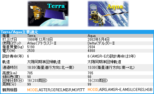
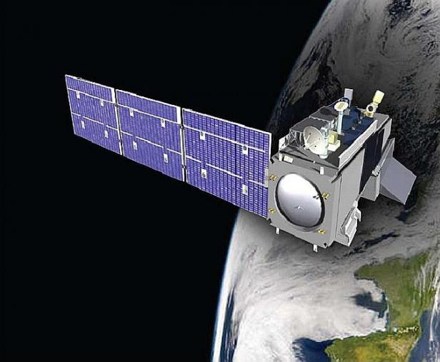
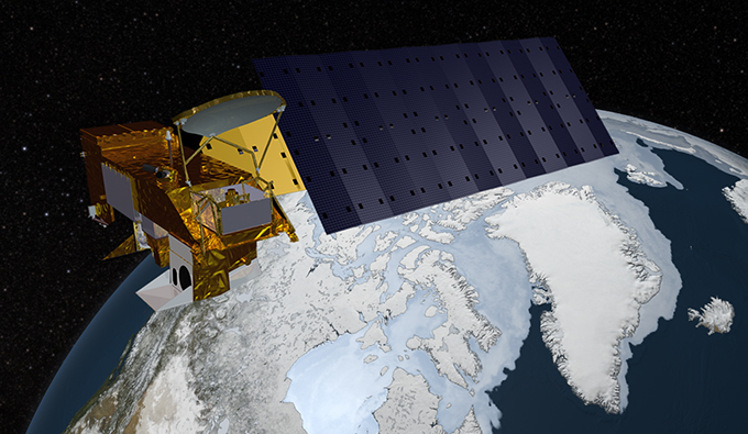
Terra/Aqua/Suomi-NPP earth observing satellites

Terra/Aqua are the earth observation satellites belonging to NASA
equipped with MODIS, Moderate Resolution Imaging Spectroradiometer.
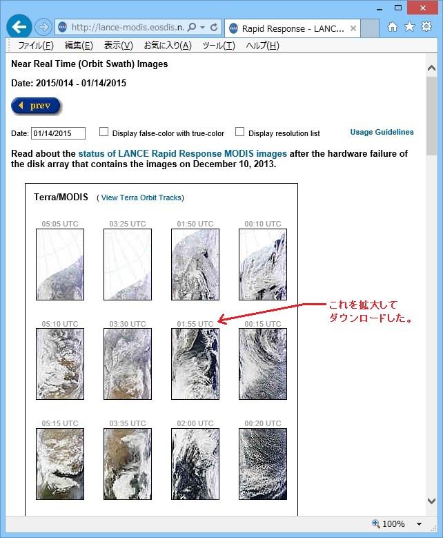
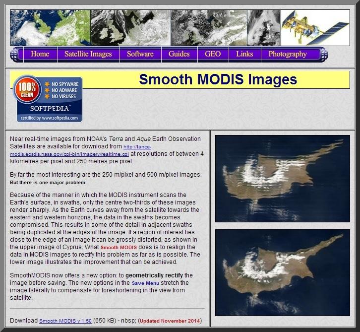
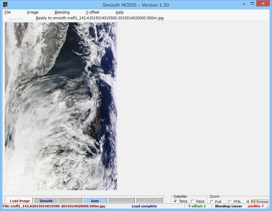
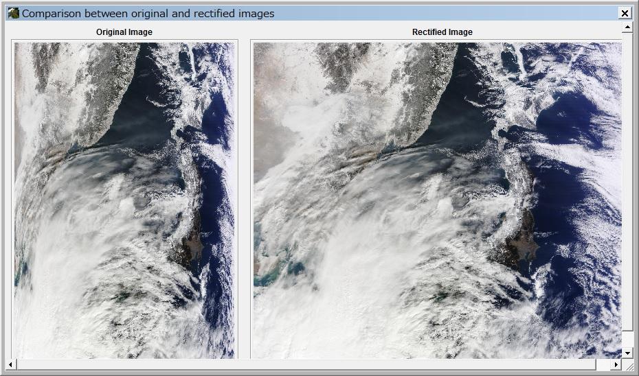
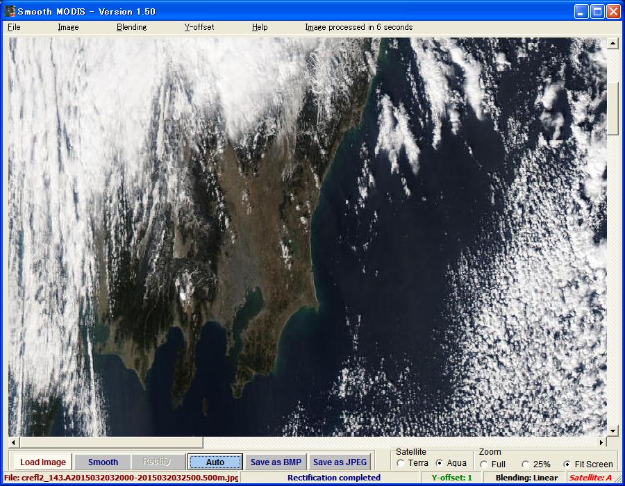
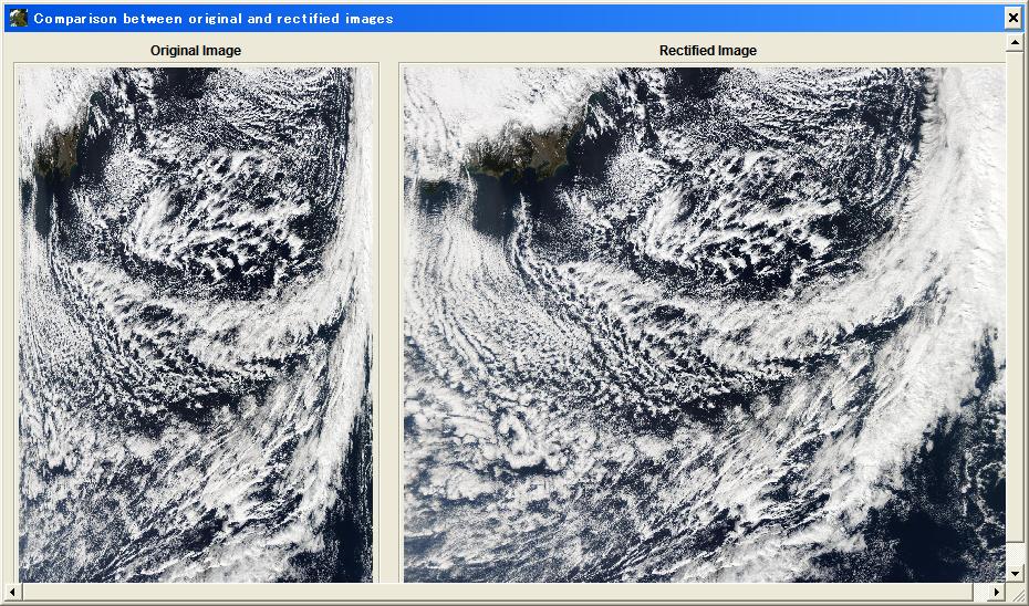
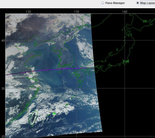
 I modified the scale of the image Terra have taken Japan on 14 Jan 2015 using
"Smooth Modis" wrote by Les Hamilton.
I modified the scale of the image Terra have taken Japan on 14 Jan 2015 using
"Smooth Modis" wrote by Les Hamilton.
 http://www.eorc.jaxa.jp/hatoyama/satellite/sendata/modis_j.html
http://lance-modis.eosdis.nasa.gov/cgi-bin/imagery/realtime.cgi
http://directreadout.sci.gsfc.nasa.gov/?id=dspContent&cid=14
http://directreadout.sci.gsfc.nasa.gov/?id=dspContent&cid=15
http://kuroshio.eorc.jaxa.jp/ADEOS/mod_nrt_new/index.html
http://myweb.tiscali.co.uk/wxsatellite/modis.htm
http://www.restec.or.jp/satellite/terra
http://www.restec.or.jp/satellite/aqua
http://modis.gsfc.nasa.gov/
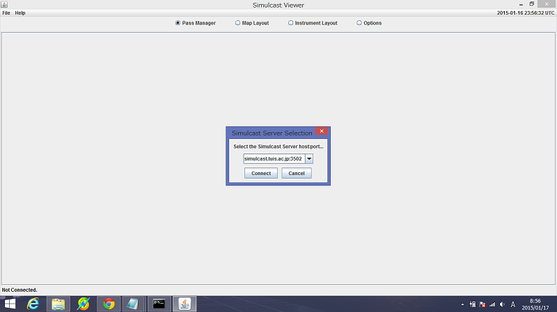
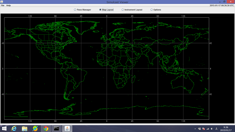
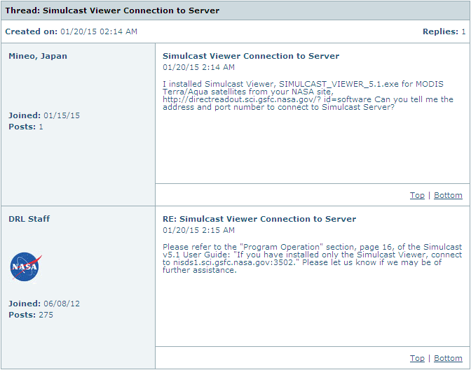
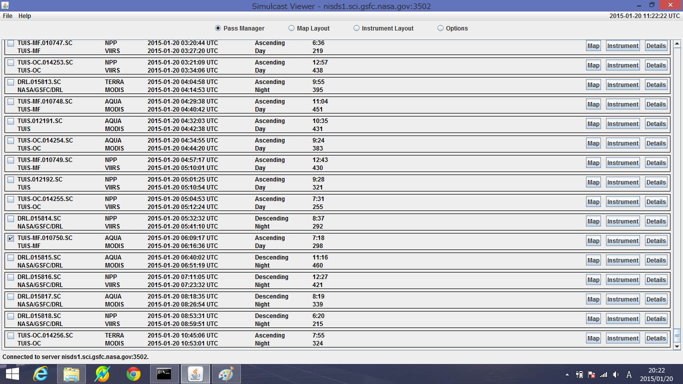
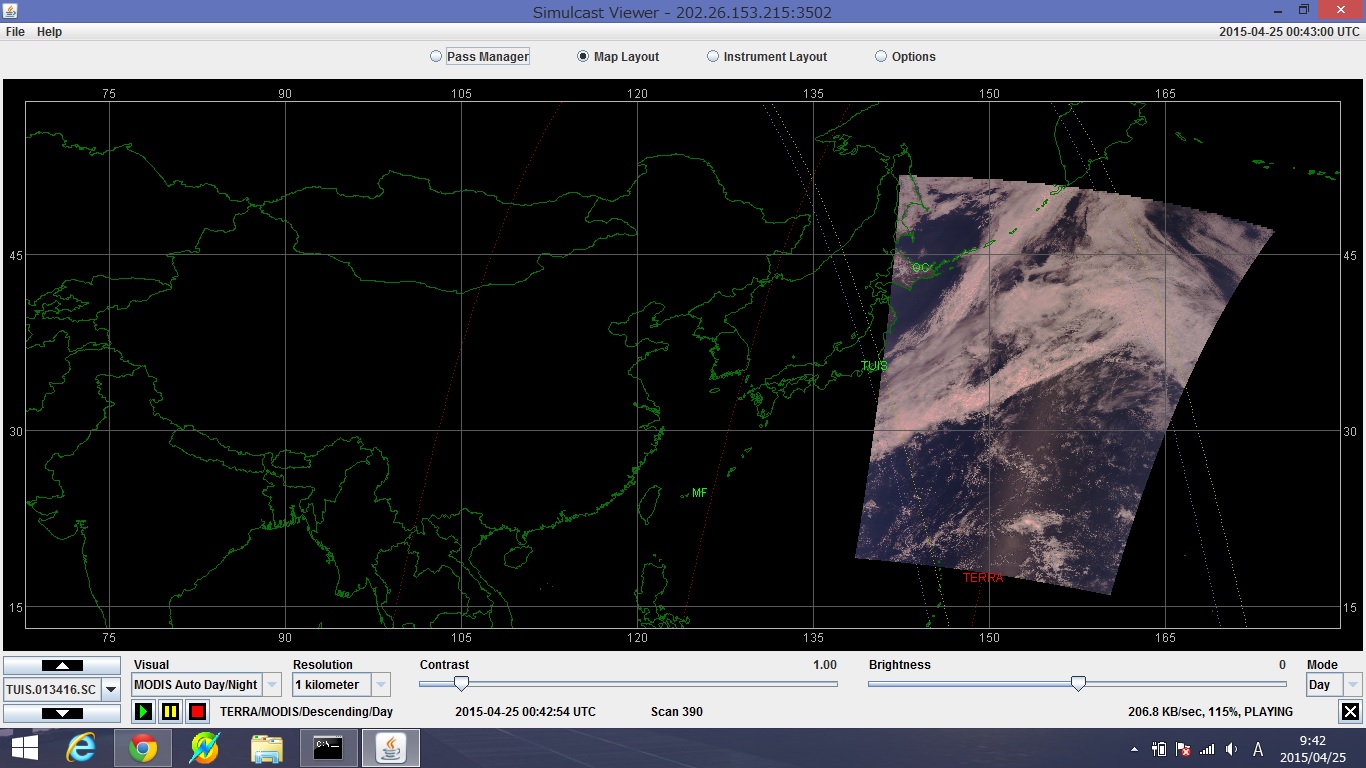
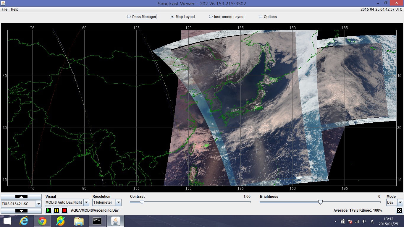
I think the earth image can be obtained in real time using "Simulcast Viewer"
that NASA has been open to the public.
http://directreadout.sci.gsfc.nasa.gov/?id=software
http://e-asia2.tuis.ac.jp/browse/HowToSimulcastV3.pdf
I installed Java 8 Update 25 (64bit), jre-8u25-windows-x64.exe in Windows8.1 64bit
PC, then I could install also Simulcast Viewer. I found that I can not install it
in Windows8.1 32bit PC at the later date. http://java.com/ja/download/manual.jsp
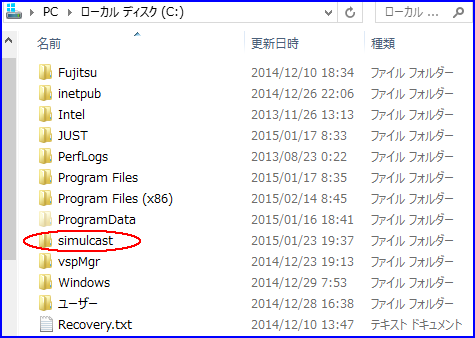
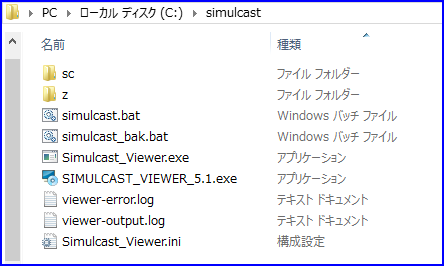
I reinstalled Simulcast folder from C:\Plogrum Files\... to C:\simulcast\...,
and I renamed the file name from "Simulcast Viewer.exe, Simulcast Viewer.ini"
to "Simulcast_Viewer.exe, Simulcast_Viewer.ini". I can't connect to the server yet.
http://www.eorc.jaxa.jp/hatoyama/satellite/sendata/modis_j.html
http://lance-modis.eosdis.nasa.gov/cgi-bin/imagery/realtime.cgi
http://directreadout.sci.gsfc.nasa.gov/?id=dspContent&cid=14
http://directreadout.sci.gsfc.nasa.gov/?id=dspContent&cid=15
http://kuroshio.eorc.jaxa.jp/ADEOS/mod_nrt_new/index.html
http://myweb.tiscali.co.uk/wxsatellite/modis.htm
http://www.restec.or.jp/satellite/terra
http://www.restec.or.jp/satellite/aqua
http://modis.gsfc.nasa.gov/
I think the earth image can be obtained in real time using "Simulcast Viewer"
that NASA has been open to the public.
http://directreadout.sci.gsfc.nasa.gov/?id=software
http://e-asia2.tuis.ac.jp/browse/HowToSimulcastV3.pdf
I installed Java 8 Update 25 (64bit), jre-8u25-windows-x64.exe in Windows8.1 64bit
PC, then I could install also Simulcast Viewer. I found that I can not install it
in Windows8.1 32bit PC at the later date. http://java.com/ja/download/manual.jsp
I reinstalled Simulcast folder from C:\Plogrum Files\... to C:\simulcast\...,
and I renamed the file name from "Simulcast Viewer.exe, Simulcast Viewer.ini"
to "Simulcast_Viewer.exe, Simulcast_Viewer.ini". I can't connect to the server yet.
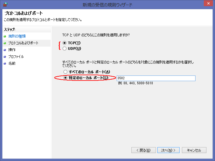
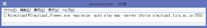 simulcast.bat
C:\simulcast\Simulcast_Viewer.exe -maximize -auto_play map -server_choice simulcast.tuis.ac.jp:3502
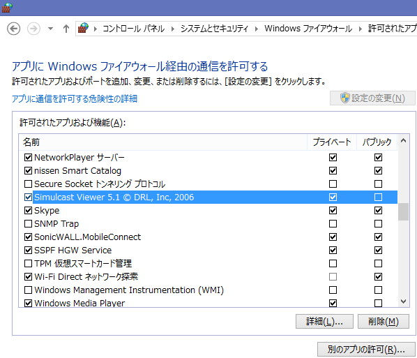
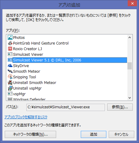
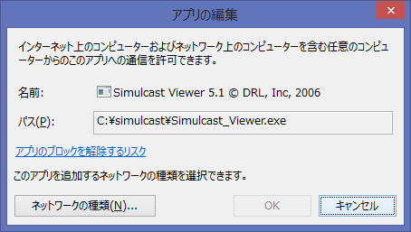
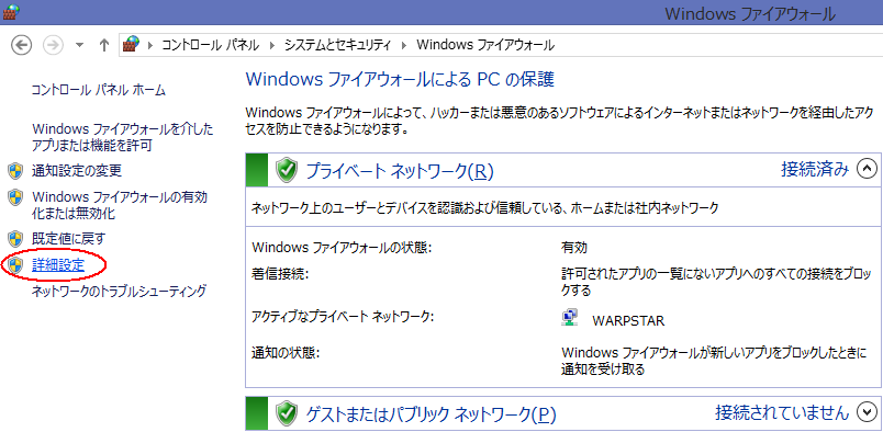
Control Panel -> System Security -> Windows Firewall -> Allowed Programs
-> Allow programs to communicate through Windows Firewall -> Change settings
-> Allow another program -> Select "Simulcast Viewer"
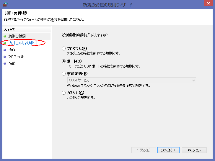
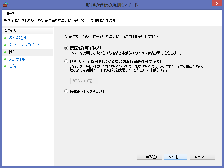
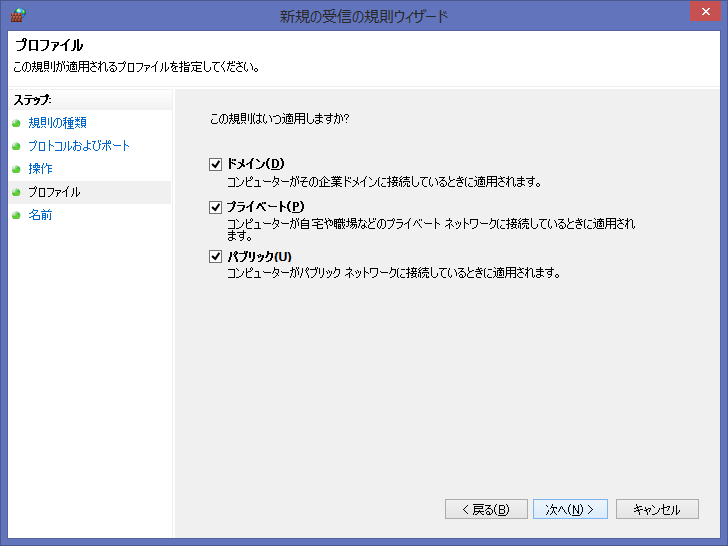
The following Port experiments do not necessarily need to be performed.
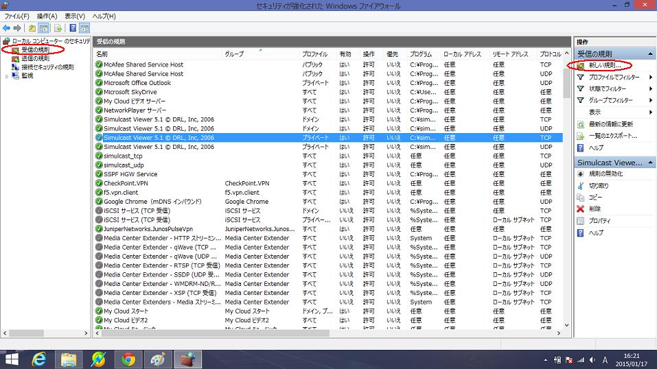
Control Panel -> System Security -> Windows Firewall -> Advanced Settings
Inbound Rules -> New Rules -> Port -> Select TCP or UDP -> Enter Specific Local Ports Number ->
Select either Allow the Connection, Allow the Connection If Secure. -> Select either Domain or Private ->
Enter a Name and Description of the rule. -> Finish (The server was restored later.)
simulcast.bat
C:\simulcast\Simulcast_Viewer.exe -maximize -auto_play map -server_choice simulcast.tuis.ac.jp:3502
Control Panel -> System Security -> Windows Firewall -> Allowed Programs
-> Allow programs to communicate through Windows Firewall -> Change settings
-> Allow another program -> Select "Simulcast Viewer"
The following Port experiments do not necessarily need to be performed.
Control Panel -> System Security -> Windows Firewall -> Advanced Settings
Inbound Rules -> New Rules -> Port -> Select TCP or UDP -> Enter Specific Local Ports Number ->
Select either Allow the Connection, Allow the Connection If Secure. -> Select either Domain or Private ->
Enter a Name and Description of the rule. -> Finish (The server was restored later.)
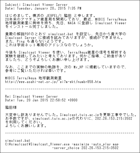
 I received a reply mail from NASA. When I re-entered the server number in simulcast.bat,
I could connect to NASA server. Because this image is over US, so The next challenge is that
how to be able to display the image over Japan. I may need to connect to a Japanese server.
https://directreadout.sci.gsfc.nasa.gov/?id=forum
I received a reply mail from NASA. When I re-entered the server number in simulcast.bat,
I could connect to NASA server. Because this image is over US, so The next challenge is that
how to be able to display the image over Japan. I may need to connect to a Japanese server.
https://directreadout.sci.gsfc.nasa.gov/?id=forum
 I received a reply from ground station in Tokyo University of Information Sciences.
I must use "202.26.153.215:3502" instead of "simulcast.tuis.ac.jp" in Japan, because
of during construction of the server. "simulcast.tuis.ac.jp: 3502" server was recovered
at a later date.
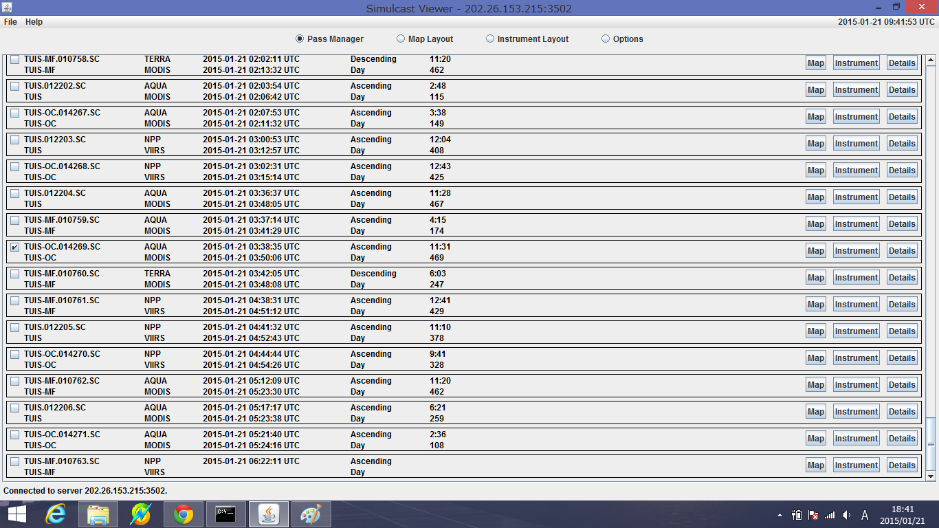
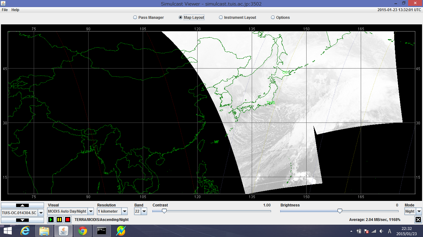
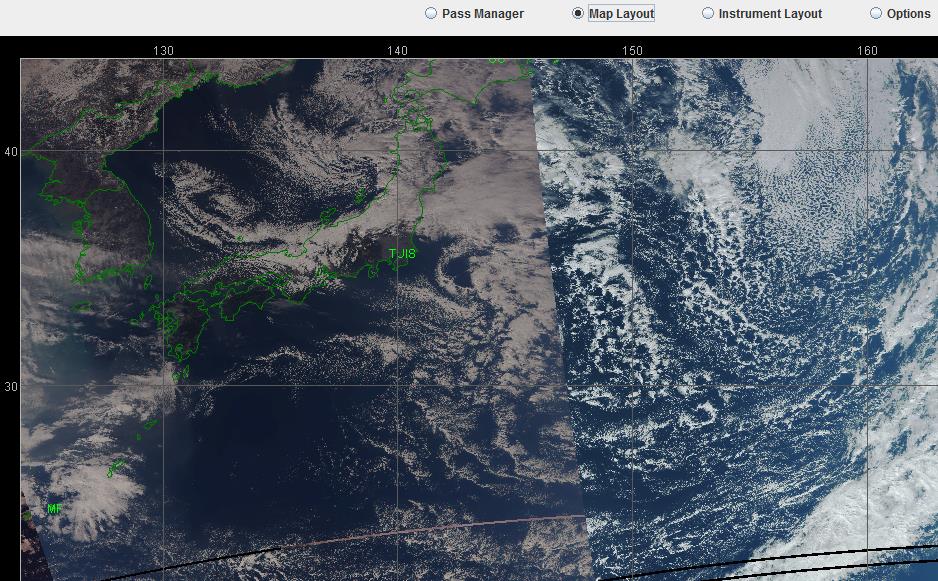
The following image was received by Tokyo University of Agriculture Okhotsk Campus
that cooperation with Tokyo University of Information Sciences in Japan. Refer, TUIS site
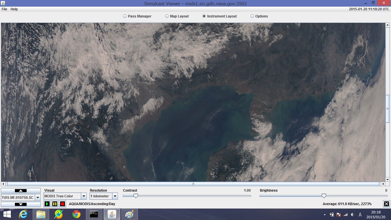
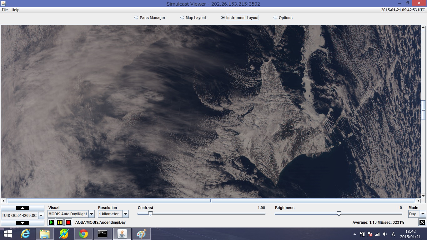
I could receive the lower image was taken on 03:38:35-03:50:06 UTC, 21 Jan 2015 from Aqua.
I received a reply from ground station in Tokyo University of Information Sciences.
I must use "202.26.153.215:3502" instead of "simulcast.tuis.ac.jp" in Japan, because
of during construction of the server. "simulcast.tuis.ac.jp: 3502" server was recovered
at a later date.
The following image was received by Tokyo University of Agriculture Okhotsk Campus
that cooperation with Tokyo University of Information Sciences in Japan. Refer, TUIS site
I could receive the lower image was taken on 03:38:35-03:50:06 UTC, 21 Jan 2015 from Aqua.
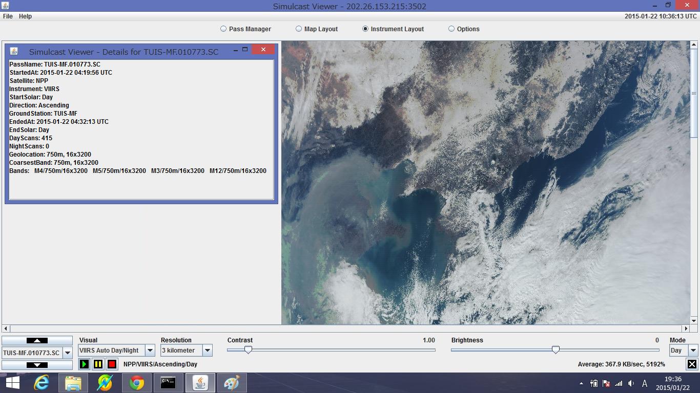
 And I decoded a picture was taken by Suomi-NPP of the earth 0bservation satellite.
NPP spacecraft lifted off aboard a United Launch Alliance Delta II rocket from
Space Launch Complex 2 at Vandenberg Air Force Base in California on 28 Oct 2011.
Visible Infrared Imaging Radiometer Suite (VIIRS) on Suomi-NPP has a spectrum
coverage from visible, near- mid- and to thermal infra-red. The following image
was received by Miyakojima Facility of Tokyo University of Agriculture that
cooperation with Tokyo University of Information Sciences. It was taken on
04:19:56-04:32:13 UTC, 22 Jan 2015 by Suomi-NPP. Whole of Japan has hidden
under the rain clouds. It's a satellite with very beautiful picture quality.
The image acquisition site, NASA.GOV.
Suomi-NPP
And I decoded a picture was taken by Suomi-NPP of the earth 0bservation satellite.
NPP spacecraft lifted off aboard a United Launch Alliance Delta II rocket from
Space Launch Complex 2 at Vandenberg Air Force Base in California on 28 Oct 2011.
Visible Infrared Imaging Radiometer Suite (VIIRS) on Suomi-NPP has a spectrum
coverage from visible, near- mid- and to thermal infra-red. The following image
was received by Miyakojima Facility of Tokyo University of Agriculture that
cooperation with Tokyo University of Information Sciences. It was taken on
04:19:56-04:32:13 UTC, 22 Jan 2015 by Suomi-NPP. Whole of Japan has hidden
under the rain clouds. It's a satellite with very beautiful picture quality.
The image acquisition site, NASA.GOV.
Suomi-NPP
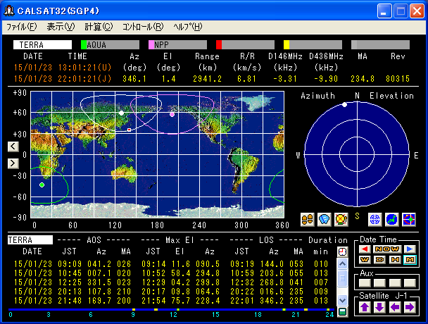
 Realtime decoding by JE9PEL
TERRA satellite on 11:13-11:22 (Ele10deg) and 12:48-13:01 UTC (Ele76deg), 23 Jan 2015.
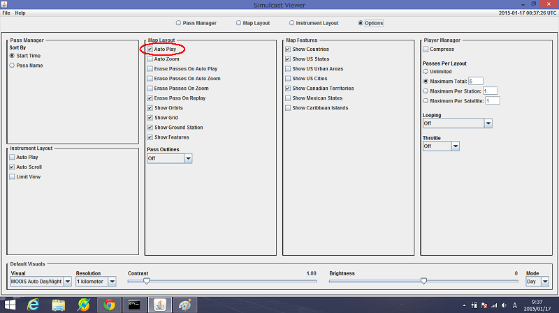
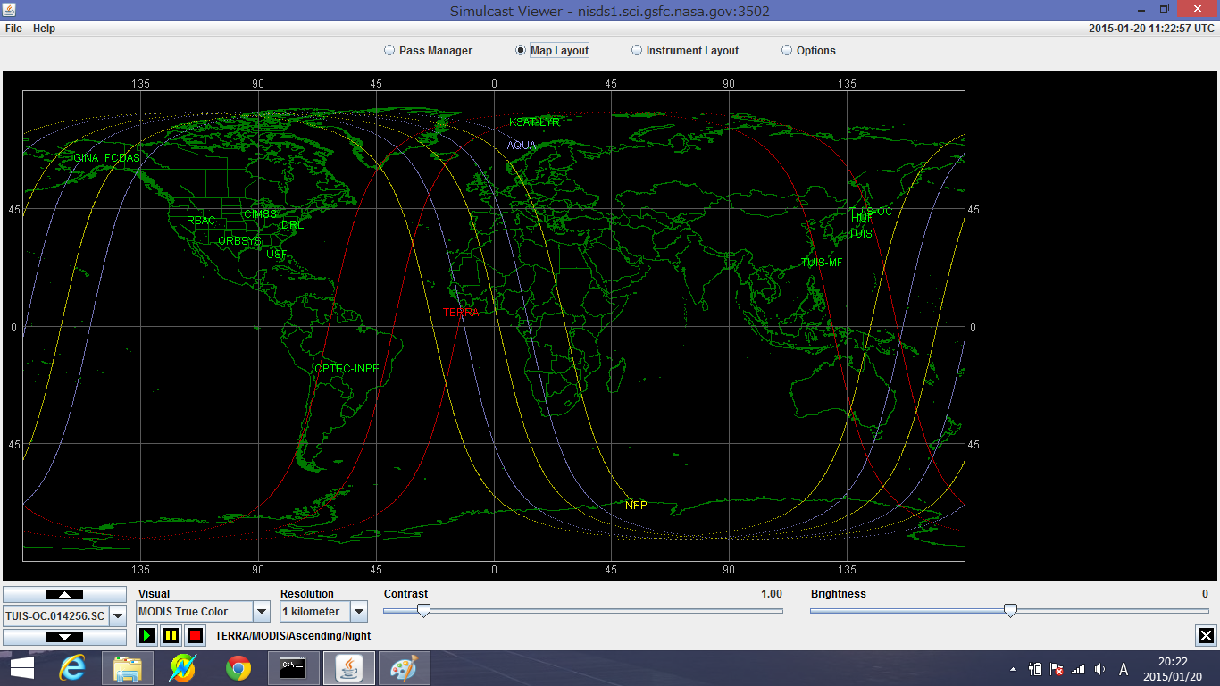
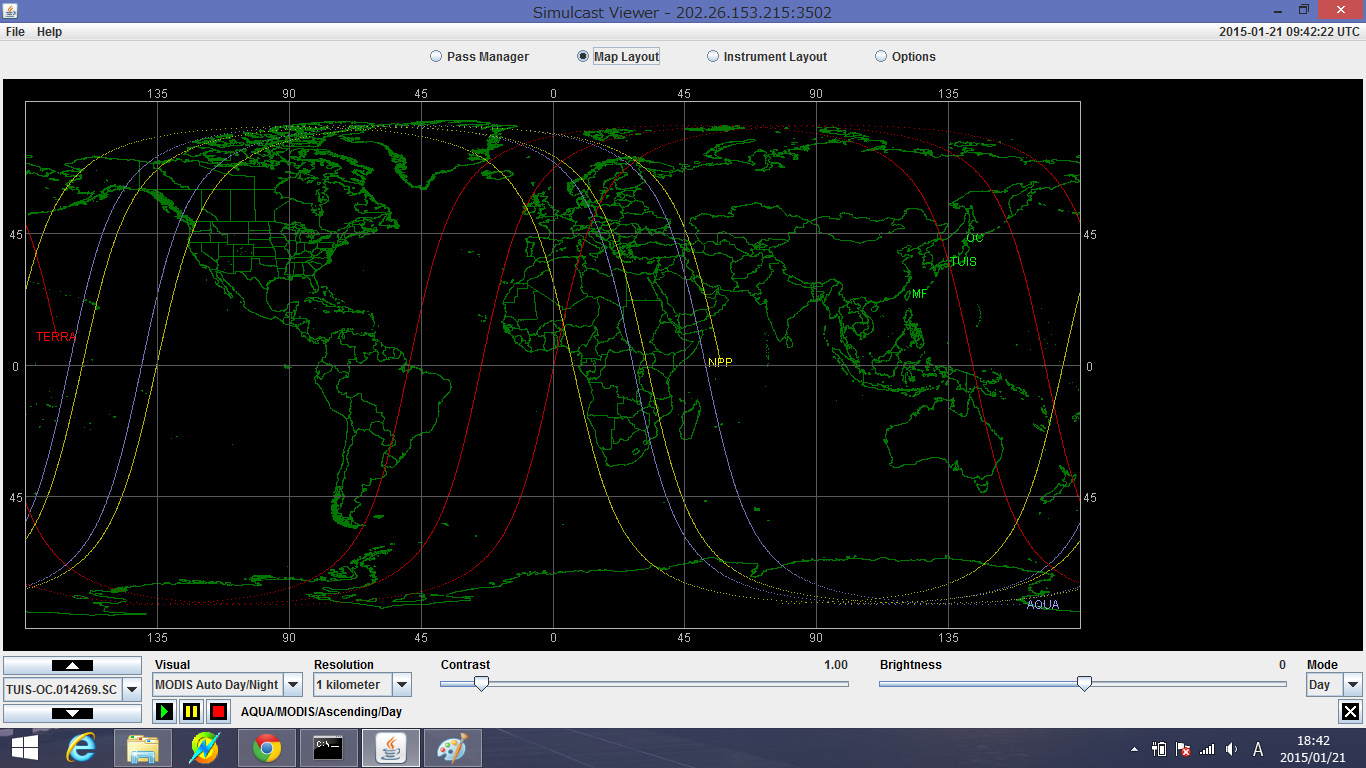
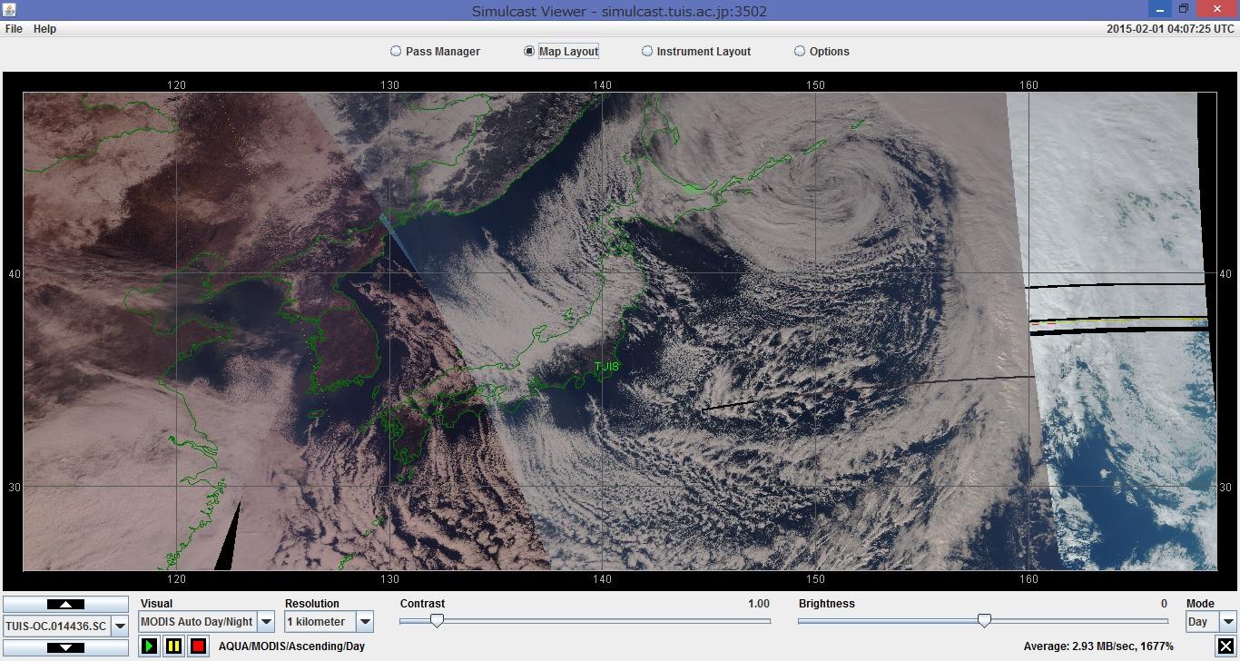
In "Simulcast Viewer - Options", Select "Auto Play" in Map_Layout. Then the images from
the satellite is constantly drawing on Map_Layout window each time the satellite comes.
TERRA 25994 1999-068A
AQUA 27424 2002-022A
NPP 37849 2011-061A
TERRA
1 25994U 99068A 15022.36386107 .00000319 00000-0 80865-4 0 383
2 25994 098.2036 098.9415 0001418 093.2279 266.9086 14.57112487802985
AQUA
1 27424U 02022A 15021.99017395 .00000602 00000-0 14380-3 0 2504
2 27424 098.2254 325.0167 0001375 087.8293 010.0400 14.57095301676535
NPP
1 37849U 11061A 15022.20005674 .00000059 00000-0 48626-4 0 9987
2 37849 098.6850 324.2115 0001631 111.3995 353.5028 14.19585389167662
Realtime decoding by JE9PEL
TERRA satellite on 11:13-11:22 (Ele10deg) and 12:48-13:01 UTC (Ele76deg), 23 Jan 2015.
In "Simulcast Viewer - Options", Select "Auto Play" in Map_Layout. Then the images from
the satellite is constantly drawing on Map_Layout window each time the satellite comes.
TERRA 25994 1999-068A
AQUA 27424 2002-022A
NPP 37849 2011-061A
TERRA
1 25994U 99068A 15022.36386107 .00000319 00000-0 80865-4 0 383
2 25994 098.2036 098.9415 0001418 093.2279 266.9086 14.57112487802985
AQUA
1 27424U 02022A 15021.99017395 .00000602 00000-0 14380-3 0 2504
2 27424 098.2254 325.0167 0001375 087.8293 010.0400 14.57095301676535
NPP
1 37849U 11061A 15022.20005674 .00000059 00000-0 48626-4 0 9987
2 37849 098.6850 324.2115 0001631 111.3995 353.5028 14.19585389167662
 Orbit Prediction today (Terra/Aqua/NPP), 24 Jan 2015
----- AOS ----- ---- Max El ---- ----- LOS ----- Dur
JST Az MA JST El Az JST Az MA min
TERRA
15/01/24 09:50 023.2 024 09:57 34.0 093.6 10:03 171.3 057 013
15/01/24 11:28 355.1 022 11:34 21.1 294.6 11:40 229.9 053 012
15/01/24 20:53 138.1 205 21:00 27.1 068.1 21:06 002.7 238 012
15/01/24 22:31 196.0 203 22:37 26.0 262.4 22:44 333.1 235 012
AQUA
15/01/24 00:26 034.1 030 00:32 16.2 095.1 00:38 151.4 060 011
15/01/24 02:03 004.0 025 02:10 42.6 279.7 02:17 210.7 060 013
15/01/24 03:44 323.5 031 03:47 01.8 301.7 03:49 284.3 043 004
15/01/24 11:30 116.9 214 11:35 13.5 067.2 11:41 012.1 241 010
15/01/24 13:06 176.6 205 13:13 55.7 265.3 13:19 342.2 240 013
15/01/24 14:49 252.2 216 14:51 02.0 274.2 14:54 296.0 229 005
15/01/24 23:35 074.7 044 23:36 00.5 083.2 23:38 096.0 050 002
NPP
15/01/24 01:23 014.4 007 01:30 76.0 081.8 01:38 190.5 045 015
15/01/24 03:04 347.8 007 03:10 12.3 300.0 03:16 247.2 036 011
15/01/24 11:05 108.6 197 11:11 10.7 061.3 11:16 013.8 225 011
15/01/24 12:43 166.2 187 12:50 86.5 286.0 12:58 347.0 225 015
15/01/24 14:26 229.5 193 14:31 07.9 272.9 14:36 314.6 218 010
15/01/24 23:28 064.9 023 23:30 01.9 084.6 23:33 104.6 036 005
Satellites Frequency (Terra/Aqua/NPP)
http://mdkenny.customer.netspace.net.au/metsat_frequencies.html
I started Simulcast Viewer in the morning 24 Jan 2015, but Viewer had froze in the
evening, and I saved the image of Terra/Aqua/Suomi-NPP in the mornig, but the central
part of the essential was the undisplayed as follows. The next day, 25 Jan 2015,
I could receive while covering the central part of Japan in all satellites.
NASA/TUIS direct reception via the internet access.
Terra 10:33-10:46JST, 25 Jan 2015, Ele 80 N-Z-WS, 8212.500MHz
Aqua 10:40-10:43JST, 25 Jan 2015, Ele 01 EN -EN, 8160.000MHz
NPP 10:48-10:57JST, 25 Jan 2015, Ele 06 E-E-EN, 7812.000MHz
Aqua 12:11-12:24JSt, 25 Jan 2015, Ele 36 SE-E-N, 8160.000MHz
Terra 12:12-12:21JST, 25 Jan 2015, Ele 07 SE-E-N, 8212.500MHz
NPP 12:24-12:39JST, 25 Jan 2015, Ele 62 SE-E-N, 7812.000MHz
Aqua 13:50-14:02JST, 25 Jan 2015, Ele 19 SW-W-WN, 8160.000MHz
NPP 14:06-14:18JST, 25 Jan 2015, Ele 14 SW-W-WN, 7812.000MHz
Orbit Prediction today (Terra/Aqua/NPP), 24 Jan 2015
----- AOS ----- ---- Max El ---- ----- LOS ----- Dur
JST Az MA JST El Az JST Az MA min
TERRA
15/01/24 09:50 023.2 024 09:57 34.0 093.6 10:03 171.3 057 013
15/01/24 11:28 355.1 022 11:34 21.1 294.6 11:40 229.9 053 012
15/01/24 20:53 138.1 205 21:00 27.1 068.1 21:06 002.7 238 012
15/01/24 22:31 196.0 203 22:37 26.0 262.4 22:44 333.1 235 012
AQUA
15/01/24 00:26 034.1 030 00:32 16.2 095.1 00:38 151.4 060 011
15/01/24 02:03 004.0 025 02:10 42.6 279.7 02:17 210.7 060 013
15/01/24 03:44 323.5 031 03:47 01.8 301.7 03:49 284.3 043 004
15/01/24 11:30 116.9 214 11:35 13.5 067.2 11:41 012.1 241 010
15/01/24 13:06 176.6 205 13:13 55.7 265.3 13:19 342.2 240 013
15/01/24 14:49 252.2 216 14:51 02.0 274.2 14:54 296.0 229 005
15/01/24 23:35 074.7 044 23:36 00.5 083.2 23:38 096.0 050 002
NPP
15/01/24 01:23 014.4 007 01:30 76.0 081.8 01:38 190.5 045 015
15/01/24 03:04 347.8 007 03:10 12.3 300.0 03:16 247.2 036 011
15/01/24 11:05 108.6 197 11:11 10.7 061.3 11:16 013.8 225 011
15/01/24 12:43 166.2 187 12:50 86.5 286.0 12:58 347.0 225 015
15/01/24 14:26 229.5 193 14:31 07.9 272.9 14:36 314.6 218 010
15/01/24 23:28 064.9 023 23:30 01.9 084.6 23:33 104.6 036 005
Satellites Frequency (Terra/Aqua/NPP)
http://mdkenny.customer.netspace.net.au/metsat_frequencies.html
I started Simulcast Viewer in the morning 24 Jan 2015, but Viewer had froze in the
evening, and I saved the image of Terra/Aqua/Suomi-NPP in the mornig, but the central
part of the essential was the undisplayed as follows. The next day, 25 Jan 2015,
I could receive while covering the central part of Japan in all satellites.
NASA/TUIS direct reception via the internet access.
Terra 10:33-10:46JST, 25 Jan 2015, Ele 80 N-Z-WS, 8212.500MHz
Aqua 10:40-10:43JST, 25 Jan 2015, Ele 01 EN -EN, 8160.000MHz
NPP 10:48-10:57JST, 25 Jan 2015, Ele 06 E-E-EN, 7812.000MHz
Aqua 12:11-12:24JSt, 25 Jan 2015, Ele 36 SE-E-N, 8160.000MHz
Terra 12:12-12:21JST, 25 Jan 2015, Ele 07 SE-E-N, 8212.500MHz
NPP 12:24-12:39JST, 25 Jan 2015, Ele 62 SE-E-N, 7812.000MHz
Aqua 13:50-14:02JST, 25 Jan 2015, Ele 19 SW-W-WN, 8160.000MHz
NPP 14:06-14:18JST, 25 Jan 2015, Ele 14 SW-W-WN, 7812.000MHz

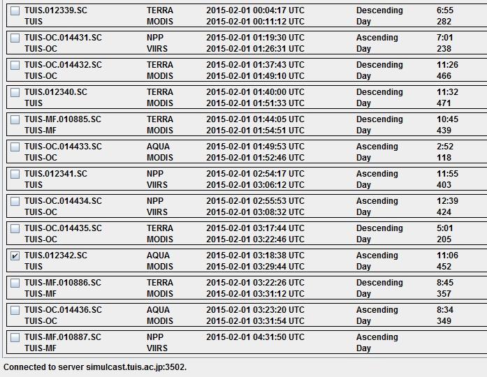
 Terra/Aqua/Suomi-NPP, 1 Feb 2015
----- AOS ----- ---- Max El ---- ----- LOS ----- Dur
DATE JST AZ MA JST El Az JST Az MA min Sats
15/02/01 09:03 043.7 046 09:08 09.7 092.2 09:13 139.4 072 010 TERRA
15/02/01 10:21 056.8 230 10:21 00.2 052.9 10:22 045.2 234 001 NPP
15/02/01 10:39 008.7 040 10:46 68.9 286.7 10:52 200.4 074 013 TERRA
15/02/01 10:45 075.3 243 10:47 01.7 057.9 10:50 036.3 254 004 AQUA
15/02/01 11:53 138.1 208 12:00 31.3 063.7 12:07 359.0 243 014 NPP
15/02/01 12:17 148.8 225 12:24 41.9 078.7 12:30 357.1 003 013 AQUA
15/02/01 12:19 335.1 042 12:23 05.6 298.3 12:26 266.1 062 007 TERRA
15/02/01 13:33 194.4 204 13:40 28.3 265.7 13:47 333.5 239 014 NPP
15/02/01 13:56 208.5 225 14:02 16.5 265.5 14:08 326.3 255 011 AQUA
Terra/Aqua/Suomi-NPP, 1 Feb 2015
----- AOS ----- ---- Max El ---- ----- LOS ----- Dur
DATE JST AZ MA JST El Az JST Az MA min Sats
15/02/01 09:03 043.7 046 09:08 09.7 092.2 09:13 139.4 072 010 TERRA
15/02/01 10:21 056.8 230 10:21 00.2 052.9 10:22 045.2 234 001 NPP
15/02/01 10:39 008.7 040 10:46 68.9 286.7 10:52 200.4 074 013 TERRA
15/02/01 10:45 075.3 243 10:47 01.7 057.9 10:50 036.3 254 004 AQUA
15/02/01 11:53 138.1 208 12:00 31.3 063.7 12:07 359.0 243 014 NPP
15/02/01 12:17 148.8 225 12:24 41.9 078.7 12:30 357.1 003 013 AQUA
15/02/01 12:19 335.1 042 12:23 05.6 298.3 12:26 266.1 062 007 TERRA
15/02/01 13:33 194.4 204 13:40 28.3 265.7 13:47 333.5 239 014 NPP
15/02/01 13:56 208.5 225 14:02 16.5 265.5 14:08 326.3 255 011 AQUA
 Terra/Aqua/Suomi-NPP, 21 Mar 2015
TUIS Tokyo University of Information Sciences Ground St. (Chiba City)
TUIS-OC Tokyo University of Agriculture, Okhotsk Campus (Abashiri City)
TUIS-MF Tokyo University of Agriculture, Miyakojima Facility (Miyakojima City)
Simulcast Viewer, developed by NASA Direct Readout Laboratory (DRL)
Optiones - Map Layout - Auto Play
Optiones - Player Manager - Maxium Total: 10
TERRA 8212.500MHz
AQUA 8160.000MHz
NPP 7812.000MHz
----- AOS ----- ---- Max El ---- ----- LOS ----- Dur
DATE JST AZ MA JST El Az JST Az MA min Sats
15/03/21 09:03 043.6 020 09:08 09.6 092.0 09:13 139.2 045 010 TERRA
15/03/21 10:20 058.9 251 10:21 00.3 051.2 10:22 043.5 000 002 NPP
15/03/21 10:39 008.8 013 10:46 69.1 288.8 10:52 200.4 047 013 TERRA
15/03/21 10:45 074.5 219 10:47 01.6 057.1 10:50 035.6 231 004 AQUA
15/03/21 11:52 138.9 229 11:59 31.5 069.6 12:06 359.7 008 014 NPP
15/03/21 12:17 148.3 202 12:24 41.5 075.4 12:30 357.1 235 013 AQUA
15/03/21 12:19 335.3 015 12:23 05.6 298.5 12:27 262.7 036 008 TERRA
15/03/21 13:32 193.6 225 13:39 28.2 260.3 13:46 332.6 005 014 NPP
15/03/21 13:56 206.2 201 14:02 16.7 267.0 14:08 326.9 232 012 AQUA
Aqua/MODIS earth observing satellite
Aqua, Latin for water, is a NASA Earth Science satellite mission named for
the large amount of information that the mission is collecting about the
Earth's water cycle, including evaporation from the oceans, water vapor in
the atmosphere, clouds, precipitation, soil moisture, sea ice, land ice,
and snow cover on the land and ice. (Quated from NASA saite)
http://lance-modis.eosdis.nasa.gov/cgi-bin/imagery/realtime.cgi
http://myweb.tiscali.co.uk/wxsatellite/modis.htm
http://global.jaxa.jp/projects/sat/aqua/
http://aqua.nasa.gov/
[complement1]
NASA Site
Smooth Modis
Simulcast Viewer
[complement2]
Terra 09:32-09:44JST, 25 Apr 2015, Ele 21 NE-E-ES 8212.500MHz
NPP 10:58-11:08JST, 25 Apr 2015, Ele 9 E-EN-N 7812.000MHz
Terra 11:09-11:22JST, 25 Apr 2015, Ele 33 N-W-WS 8212.500MHz
Aqua 11:12-11:21JST, 25 Apr 2015, Ele 9 E-EN-N 8160.000MHz
NPP 12:35-12:49JST, 25 Apr 2015, Ele 79 S-Z-N 7812.000MHz
Aquq 12:47-13:00JST, 25 Apr 2015, Ele 84 S-W-N 8160.000MHz
NPP 14:17-14:28JST, 25 Apr 2015, Ele 10 SW-W-WN 7812.000MHz
AQUA 14:27-14:36JST, 25 Apr 2015, Ele 7 SW-W-WN 8160.000MHz
(a) (b) (c)
Terra/Aqua/Suomi-NPP, 21 Mar 2015
TUIS Tokyo University of Information Sciences Ground St. (Chiba City)
TUIS-OC Tokyo University of Agriculture, Okhotsk Campus (Abashiri City)
TUIS-MF Tokyo University of Agriculture, Miyakojima Facility (Miyakojima City)
Simulcast Viewer, developed by NASA Direct Readout Laboratory (DRL)
Optiones - Map Layout - Auto Play
Optiones - Player Manager - Maxium Total: 10
TERRA 8212.500MHz
AQUA 8160.000MHz
NPP 7812.000MHz
----- AOS ----- ---- Max El ---- ----- LOS ----- Dur
DATE JST AZ MA JST El Az JST Az MA min Sats
15/03/21 09:03 043.6 020 09:08 09.6 092.0 09:13 139.2 045 010 TERRA
15/03/21 10:20 058.9 251 10:21 00.3 051.2 10:22 043.5 000 002 NPP
15/03/21 10:39 008.8 013 10:46 69.1 288.8 10:52 200.4 047 013 TERRA
15/03/21 10:45 074.5 219 10:47 01.6 057.1 10:50 035.6 231 004 AQUA
15/03/21 11:52 138.9 229 11:59 31.5 069.6 12:06 359.7 008 014 NPP
15/03/21 12:17 148.3 202 12:24 41.5 075.4 12:30 357.1 235 013 AQUA
15/03/21 12:19 335.3 015 12:23 05.6 298.5 12:27 262.7 036 008 TERRA
15/03/21 13:32 193.6 225 13:39 28.2 260.3 13:46 332.6 005 014 NPP
15/03/21 13:56 206.2 201 14:02 16.7 267.0 14:08 326.9 232 012 AQUA
Aqua/MODIS earth observing satellite
Aqua, Latin for water, is a NASA Earth Science satellite mission named for
the large amount of information that the mission is collecting about the
Earth's water cycle, including evaporation from the oceans, water vapor in
the atmosphere, clouds, precipitation, soil moisture, sea ice, land ice,
and snow cover on the land and ice. (Quated from NASA saite)
http://lance-modis.eosdis.nasa.gov/cgi-bin/imagery/realtime.cgi
http://myweb.tiscali.co.uk/wxsatellite/modis.htm
http://global.jaxa.jp/projects/sat/aqua/
http://aqua.nasa.gov/
[complement1]
NASA Site
Smooth Modis
Simulcast Viewer
[complement2]
Terra 09:32-09:44JST, 25 Apr 2015, Ele 21 NE-E-ES 8212.500MHz
NPP 10:58-11:08JST, 25 Apr 2015, Ele 9 E-EN-N 7812.000MHz
Terra 11:09-11:22JST, 25 Apr 2015, Ele 33 N-W-WS 8212.500MHz
Aqua 11:12-11:21JST, 25 Apr 2015, Ele 9 E-EN-N 8160.000MHz
NPP 12:35-12:49JST, 25 Apr 2015, Ele 79 S-Z-N 7812.000MHz
Aquq 12:47-13:00JST, 25 Apr 2015, Ele 84 S-W-N 8160.000MHz
NPP 14:17-14:28JST, 25 Apr 2015, Ele 10 SW-W-WN 7812.000MHz
AQUA 14:27-14:36JST, 25 Apr 2015, Ele 7 SW-W-WN 8160.000MHz
(a) (b) (c)
 http://www.eorc.jaxa.jp/hatoyama/satellite/sendata/modis_j.html
http://lance-modis.eosdis.nasa.gov/cgi-bin/imagery/realtime.cgi
http://myweb.tiscali.co.uk/wxsatellite/modis.htm
http://www.satnavi.jaxa.jp/project/aqua/
http://www.jaxa.jp/projects/sat/aqua/
http://www.restec.or.jp/satellite/aqua
http://aqua.nasa.gov/
Aqua Satellite
http://www.eorc.jaxa.jp/hatoyama/satellite/sendata/modis_j.html
http://lance-modis.eosdis.nasa.gov/cgi-bin/imagery/realtime.cgi
http://myweb.tiscali.co.uk/wxsatellite/modis.htm
http://www.satnavi.jaxa.jp/project/aqua/
http://www.jaxa.jp/projects/sat/aqua/
http://www.restec.or.jp/satellite/aqua
http://aqua.nasa.gov/
Aqua Satellite
 (C)NASA
[complement3]
NPP 14:06-14:18JST, 3 Jan 2017, Ele 11 SW-W-WN
Aqua 13:11-13:24JST, 4 Jan 2017, Ele 48 S-W-WN
(C)NASA
[complement3]
NPP 14:06-14:18JST, 3 Jan 2017, Ele 11 SW-W-WN
Aqua 13:11-13:24JST, 4 Jan 2017, Ele 48 S-W-WN
 TUIS.021362.sc NPP VIIRS, 2017-01-04 03:06:43-03:14:04UTC, Resolution 750meter
Southeast Russia and Hokkaido in Japan
[complement4]
TUIS.021362.sc NPP VIIRS, 2017-01-04 03:06:43-03:14:04UTC, Resolution 750meter
Southeast Russia and Hokkaido in Japan
[complement4]
 (C)NASA
JPSS-1(NOAA-20)
15Mbit/s, X-Band feed at 7812.000MHz
http://spaceflight101.com/jpss-1/jpss-1/
http://www.wmo-sat.info/oscar/satellites/view/208
Simulcast Viewer was updated to Ver 6.0 corresponding to JPSS-1(NOAA-20).
However, the software compatible with Windows 64bit is the one before Ver 5.1.
(C)NASA
JPSS-1(NOAA-20)
15Mbit/s, X-Band feed at 7812.000MHz
http://spaceflight101.com/jpss-1/jpss-1/
http://www.wmo-sat.info/oscar/satellites/view/208
Simulcast Viewer was updated to Ver 6.0 corresponding to JPSS-1(NOAA-20).
However, the software compatible with Windows 64bit is the one before Ver 5.1.


 Back to Top
 Back to Home Page