Duchifat-1 registration

 How to register to Israel satellite Duchifat-1 server, JE1CVL has introduced.
I could obtain the Symbol Table ID and Symbol Code in exactly the same way.
Then, I confirmed that it obtained the "APRS compressed packet" at the end of
the stage. Because the process is a little difficult, JE9PEL describe here.
1. Duchifat-1 HP, http://www.h-space-lab.org/php/index-en.php
2. Click "Registration" in the top of HP.
3. Input FirstName, LastName, CallSign, eMail and click "get code" button.
4. "Verify" will appear immediately. Receive an email immediately.
5. Because the 32-digit "code number" is written in the mail titled
"Code Verification". Copy this "code number" and paste it in the box
of "Verify". Click on "submit" button below it.
6. "Congratulations! Symbol Table ID, a Symbol Code" appears one character
at a time, The second confirmation email will come.
7. Continuing further, click "APRS Encoder" in the top of HP.
8. Enter each of "Callsign, Latitude, Longitude" and click "send" button
below it. The 14-digit "APRS compressed packet" is displayed. The first
digit is "!", 14th digit is "_", and 2nd digit is "Symbol Table ID",
11th digit is "Symbol Code". The third confirmation email will come.
9. It seems sufficient to send this 14-digit data to the satellite.
Duchifat-1
Herzliya Science Center, Israel
Uplink 435.220MHz, Downlink 145.825/145.980MHz 1200bps AFSK,BPSK,CW
DUCHIFAT1 uses 1200bd AFSK uplink on 435.220MHz (UHF), and 1200bd BPSK
downlink on 145.980MHz (VHF).
Doppler shift is up to about +/-10KHz in UHF, and +/-3.3KHz in VHF and
slight thermal frequency deviations is possible, below 1KHz. User tran_
smit mode is usually FM for transmitting the 1200 baud AFSK audio from
TinyTrak4 to the satellite. User receive mode is USB for the ability to
decode the 1200 BPSK telemetry. DUCHIFAT1 sends BPSK modulated telemetry
every 20 seconds, with relatively long quiet pause between transmissions.
It also sends a Morse code beacon every 1 minute saying "hi de duchifat".
a) Send your packets during the quiet pauses and listen to the
satellite's downlink. If the satellite receives your packet
you will hear an immediate very short transmission of your
packet being retransmitted by the satellite.
b) Stop sending additional packets immediately after hearing
your packet retransmitted by the satellite, and let other
HAM operators try.
c) Do not transmit to DUCHIFAT1 when it is below 50degrees in
this operating scenario.
d) Use a high packets sending rate of up to every 7 seconds but
please BE FAIR to the other users, and STOP SENDING packets
immediately after you hear the satellite retransmits your
packet for the first time.
http://www.h-space-lab.org/php/index-en.php
http://www.h-space-lab.org/download/Duchifat1%20Terms%20Of%20Use.pdf
http://www.h-space-lab.org/download/APRS%20generator%20manual.pdf
http://www.h-space-lab.org/download/Configuring%20TinyTrak4.pdf
http://www.h-space-lab.org/download/walk%20through.pdf
http://blog.goo.ne.jp/je1cvl/d/20150828
[Supplement]
How to register to Israel satellite Duchifat-1 server, JE1CVL has introduced.
I could obtain the Symbol Table ID and Symbol Code in exactly the same way.
Then, I confirmed that it obtained the "APRS compressed packet" at the end of
the stage. Because the process is a little difficult, JE9PEL describe here.
1. Duchifat-1 HP, http://www.h-space-lab.org/php/index-en.php
2. Click "Registration" in the top of HP.
3. Input FirstName, LastName, CallSign, eMail and click "get code" button.
4. "Verify" will appear immediately. Receive an email immediately.
5. Because the 32-digit "code number" is written in the mail titled
"Code Verification". Copy this "code number" and paste it in the box
of "Verify". Click on "submit" button below it.
6. "Congratulations! Symbol Table ID, a Symbol Code" appears one character
at a time, The second confirmation email will come.
7. Continuing further, click "APRS Encoder" in the top of HP.
8. Enter each of "Callsign, Latitude, Longitude" and click "send" button
below it. The 14-digit "APRS compressed packet" is displayed. The first
digit is "!", 14th digit is "_", and 2nd digit is "Symbol Table ID",
11th digit is "Symbol Code". The third confirmation email will come.
9. It seems sufficient to send this 14-digit data to the satellite.
Duchifat-1
Herzliya Science Center, Israel
Uplink 435.220MHz, Downlink 145.825/145.980MHz 1200bps AFSK,BPSK,CW
DUCHIFAT1 uses 1200bd AFSK uplink on 435.220MHz (UHF), and 1200bd BPSK
downlink on 145.980MHz (VHF).
Doppler shift is up to about +/-10KHz in UHF, and +/-3.3KHz in VHF and
slight thermal frequency deviations is possible, below 1KHz. User tran_
smit mode is usually FM for transmitting the 1200 baud AFSK audio from
TinyTrak4 to the satellite. User receive mode is USB for the ability to
decode the 1200 BPSK telemetry. DUCHIFAT1 sends BPSK modulated telemetry
every 20 seconds, with relatively long quiet pause between transmissions.
It also sends a Morse code beacon every 1 minute saying "hi de duchifat".
a) Send your packets during the quiet pauses and listen to the
satellite's downlink. If the satellite receives your packet
you will hear an immediate very short transmission of your
packet being retransmitted by the satellite.
b) Stop sending additional packets immediately after hearing
your packet retransmitted by the satellite, and let other
HAM operators try.
c) Do not transmit to DUCHIFAT1 when it is below 50degrees in
this operating scenario.
d) Use a high packets sending rate of up to every 7 seconds but
please BE FAIR to the other users, and STOP SENDING packets
immediately after you hear the satellite retransmits your
packet for the first time.
http://www.h-space-lab.org/php/index-en.php
http://www.h-space-lab.org/download/Duchifat1%20Terms%20Of%20Use.pdf
http://www.h-space-lab.org/download/APRS%20generator%20manual.pdf
http://www.h-space-lab.org/download/Configuring%20TinyTrak4.pdf
http://www.h-space-lab.org/download/walk%20through.pdf
http://blog.goo.ne.jp/je1cvl/d/20150828
[Supplement]
 APRS Compressed Position Report Data Format
About Duchifat-1 "Compressed Position Report Data Format", JE1CVL has an interesting
analysis. I, JE9PEL wrote previously a detailed article about "APRS MIC-E Format",
and I was a self-wrote program for calculating it. Because they are referring to the
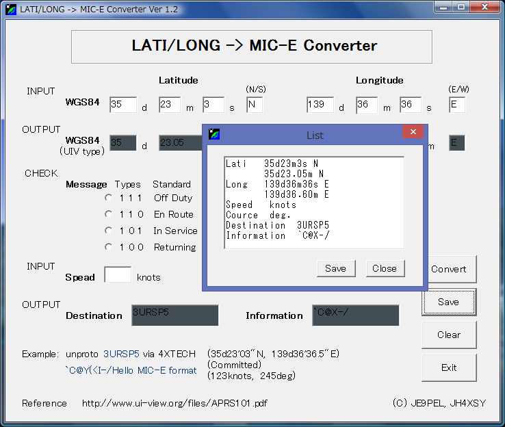
same APRS101.PDF, I think the idea is common. "MIC-E Converter (miceconv.exe)" is
automatically calculated the latitude and longitude result when you enter them.
The window of the conversion result might be hard to see overlapping with the gray
or black color in your PC. At that time, press Save button following Convert button.
Then, the converted calculation results will be pop up.
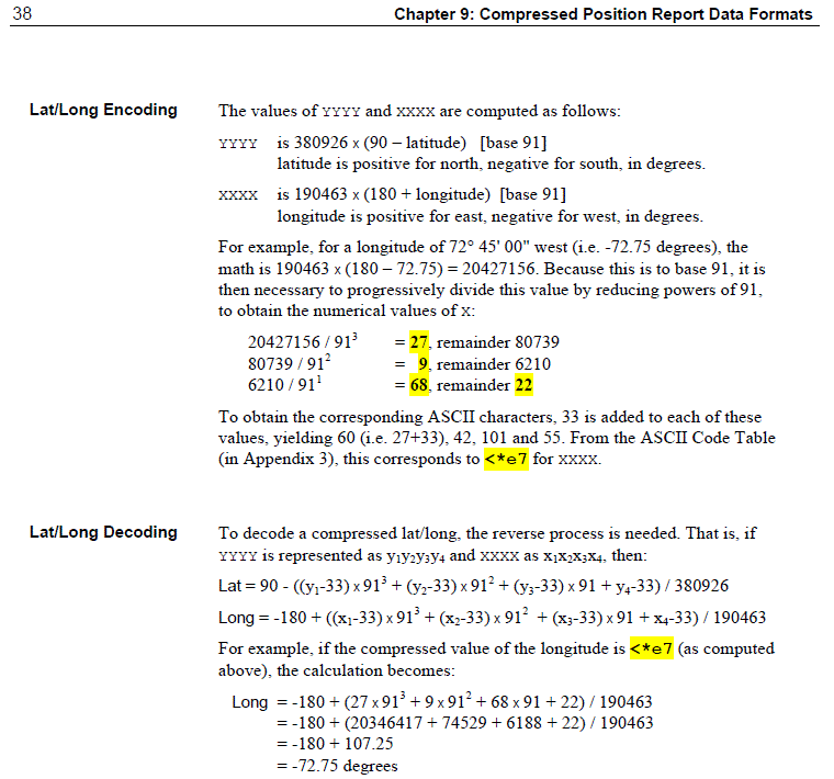
APRS Lati/Long Decoding
My compressed packet that sent to me from Duchifat-1 ground station is !"<X?%qh$$y!!_
I tried to calculate specifically using this code as follows. The result of calculating
this code after ASCII conversion, It was an exact match down to fifth places of decimals
of my QTH's latitude and longitude.
APRS compressed packet is: !"<X?%qh$$y!!_
Lati = <X?%
y1 y2 y3 y4
< X ? % = 60 88 63 37
Lati = 90-((y1-33)*91^3+(y2-33)*91^2+(y3-33)*91+(y4-33))/380926
= 90-((60-33)*91^3+(88-33)*91^2+(63-33)*91+(37-33))/380926
= 90-(27*753571+55*8281+30*91+4)/380926
= 90-(20346417+455455+2730+4)/380926
= 90-20804606/380926
= 90-54.61587
= 35.38413
Long = qh$$
x1 x2 x3 x4
q h $ $ = 113 104 36 36
Long = -180+((x1-33)*91^3+(x2-33)*91^2+(x3-33)*91+(x4-33))/190463
= -180+((113-33)*91^3+(104-33)*91^2+(36-33)*91+(36-33))/190463
= -180+(80*753571+71*8281+3*91+3)/190463
= -180+(60285680+587951+273+3)/190463
= -180+60873907/190463
= -180+319.61014
= 139.61014
[Reference]
http://www.aprs.org/doc/APRS101.PDF
http://www.ne.jp/asahi/hamradio/je9pel/miceconv.htm
http://www.ne.jp/asahi/hamradio/je9pel/miceconv.zip
http://blog.goo.ne.jp/je1cvl/d/20151004
http://blog.goo.ne.jp/je1cvl/d/20151005
APRS Compressed Position Report Data Format
About Duchifat-1 "Compressed Position Report Data Format", JE1CVL has an interesting
analysis. I, JE9PEL wrote previously a detailed article about "APRS MIC-E Format",
and I was a self-wrote program for calculating it. Because they are referring to the
same APRS101.PDF, I think the idea is common. "MIC-E Converter (miceconv.exe)" is
automatically calculated the latitude and longitude result when you enter them.
The window of the conversion result might be hard to see overlapping with the gray
or black color in your PC. At that time, press Save button following Convert button.
Then, the converted calculation results will be pop up.
APRS Lati/Long Decoding
My compressed packet that sent to me from Duchifat-1 ground station is !"<X?%qh$$y!!_
I tried to calculate specifically using this code as follows. The result of calculating
this code after ASCII conversion, It was an exact match down to fifth places of decimals
of my QTH's latitude and longitude.
APRS compressed packet is: !"<X?%qh$$y!!_
Lati = <X?%
y1 y2 y3 y4
< X ? % = 60 88 63 37
Lati = 90-((y1-33)*91^3+(y2-33)*91^2+(y3-33)*91+(y4-33))/380926
= 90-((60-33)*91^3+(88-33)*91^2+(63-33)*91+(37-33))/380926
= 90-(27*753571+55*8281+30*91+4)/380926
= 90-(20346417+455455+2730+4)/380926
= 90-20804606/380926
= 90-54.61587
= 35.38413
Long = qh$$
x1 x2 x3 x4
q h $ $ = 113 104 36 36
Long = -180+((x1-33)*91^3+(x2-33)*91^2+(x3-33)*91+(x4-33))/190463
= -180+((113-33)*91^3+(104-33)*91^2+(36-33)*91+(36-33))/190463
= -180+(80*753571+71*8281+3*91+3)/190463
= -180+(60285680+587951+273+3)/190463
= -180+60873907/190463
= -180+319.61014
= 139.61014
[Reference]
http://www.aprs.org/doc/APRS101.PDF
http://www.ne.jp/asahi/hamradio/je9pel/miceconv.htm
http://www.ne.jp/asahi/hamradio/je9pel/miceconv.zip
http://blog.goo.ne.jp/je1cvl/d/20151004
http://blog.goo.ne.jp/je1cvl/d/20151005
 Back to Top
 Back to Home Page