| | 商品番号 | J-1541 | お問い合わせ・ご注文 露蘭堂 |
| | Edward Stanford |
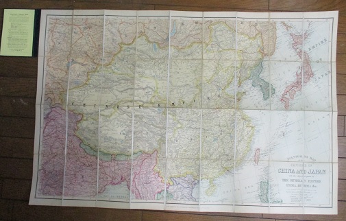
| | Stanford's Map of The Empires of China and Japan. |
| | Stanford's Map of The Empires of China and Japan with the Adjacent parts of the |
| | Russian Empire, India, Burma & c. Colored lithographic folding map backed on linen. |
| | Scale 1: 6,969,600, 110 English statue miles to 1 inch. Railways, projected railways, |
| | submarine telegraph cables, treaty ports, ports opened to trade. London, published by |
| | Edward Stanford, 30th July 1903. cloth. |
| | エドワード・スタンフォード(地図製作会社) |
| スタンフォード「中国・日本 隣接ロシア帝国、インド、ビルマなど」地図 |
| | ロンドン 1903年発行 |
| | 出版社のクロス (17.5 x 12cm) 地図の大きさ 68.5 x 104 cm | ¥27,000 |
| |
| |
Edward Stanford (1827-1904)が設立したロンドン、ブリストルの地図会社 Stanford's, Ltd. |
| が発行したカラー地図。鉄道(既設*実線)、計画鉄道路線(破線)、海底電信 |
| ケーブル、条約港、貿易港が示される。 | |
|